Communities, neighborhoods, and hamlets in and around Cowan
By L. Jarod Pearson
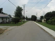
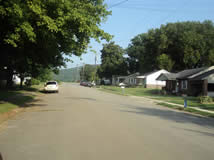
The Bottom:
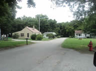 The Bottom: photo taken from South Sycamore Street The Bottom: photo taken from South Sycamore Street
The Bottom is Cowan's oldest African-American neighborhood and was the second major housing development of the Davidson, Hicks & Greene Timber Company. The Bottom is so named because of its low elevation adjacent to Boiling Fork Creek and the fill that supports the railroad right-of-way. The Bottom was subject to flooding in heavy rain until the 1950's when a concrete retaining wall was constructed by cement plant employees. A small grocery store existed in The Bottom on the southernmost end of Front Street facing the railroad tracks. The most prominent area landmark is the Rayburn Chapel A.M.E. Church, which is the second oldest church building in Cowan today. |
Centennial:
Centennial is a rural community west and south of Cowan served by Boiling Fork Creek and Norwood Creek. The most significant area landmark is the Goshen Cumberland Presbyterian Church, Franklin County's first organized church, and the related Goshen Cemetery. The first school the serve the Cowan area was also at Goshen.
Centennial is primarily and historically a farming community. Pioneer settlers in the area established the first farmer's education society in 1818 to increase productivity and tap into the growing cotton trade. That same year a mill and cotton gin was built on Norwood Creek by the Gross family. Most area farmers switched to grain production in the early 20th-Century with the help of a local granary owned and operated by the Money family.
The community was anchored by Centennial Grocery through the latter half of the 20th Century. Centennial Grocery was initially a small convenience store with gas pumps. Then, in the early 1980's, Mrs. Lill Waggoner added a kitchen with short-order lunch service. Centennial Grocery quickly became a popular hangout for residents, employees at Money Brothers Granary, customers for the nearby Vaughn Welding shop, and visitors to the legendary Judge's Gun Shop. Another local business, Reid Bus Tours, operated next door to Centennial Grocery. Between Cowan and Centennial the Evans family operated a large sawmill on Water Tank Road.
Area commerce at Centennial all but disappeared in the early 21st Century with the closing and subsequent demolition of Money Brothers Granary followed by the closing of Judge's Gun Shop and Centennial Grocery. Several farms still operate in the area, but some have been subdivided for new home construction. The population at Centennial is growing even though the community is less connected now it lacks an anchoring business.
Roughly half of the residents in Centennial are descended from some of the original pioneer settlers of Franklin County and specifically the town of Cowan. Common surnames in Centennial are Bell, Cowan, Holder, Keith, Kinningham, Knight, and Williams. |
Chocolate Row
 Chocolate Row: photo taken from East England Street Chocolate Row: photo taken from East England Street
Chocolate Row refers to a row of houses along East England Street in the southeast quadrant of Cowan. The wood frame one-family houses were built in the late 1920's to house employees of the fast-growing Davidson, Hicks & Greene Timber Company. When the houses were constructed, DH&G had an over-abundance of brown paint in storage. Since that time, the houses on East England were affectionately called Chocolate Row even though most were repainted or sided in the 1950's.
The houses at Chocolate Row are well maintained and some have shady lawns bordered by a thicket that overlooks Boiling Fork Creek. The entire neighborhood benefitted from a 2010 sidewalk expansion project. In 2009 a massive city-wide effort to demolish abandoned structures eliminated two prominent eyesores near Chocolate Row. |
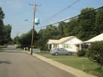
City Limits
 City Limits: photo taken from W. Cumberland Street City Limits: photo taken from W. Cumberland Street
City Limits refers to a commercial trading district on the west side of Cowan. This area developed as the growing popularity of Highway 41A created a niche for businesses with highway frontage and abundant parking.
In the post war years the City Limits was a trendy part of town with two drive-in restaurants and a roller skating rink. The automobile orientation of the district, built in an east-west orientation, contrasts with Cowan's historic downtown that was developed with a north-south orientation along the railroad.
Cowan's only liquor store has been a prominent anchor in the City Limits District for over four decades. Other well-known businesses that existed here were Jim's Drive-in, Flo's Restaurant, Cowan Roller Rink, and the Rolling Acres Motel. WZYX Radio moved from downtown to the City Limits in the early 1970's. |
Frogtown
 Frogtown: photo taken at Swain Street. Frogtown: photo taken at Swain Street.
Frogtown is a cluster of houses between the railroad yard, the railroad swamp, Mars Hill and the old Thorogood School in the northwest quadrant of Cowan. The name derives from the close proximity to the railroad swamp. Historically a black neighborhood, Frogtown once had more than two dozen houses along with a popular African-American owned business, the Railroad Inn restaurant.
Frogtown was originally accessed by Greenhaw Road giving residents easy north-south access and a direct street connection to Thorogood School and Thorogood Cemetery. However, the closure of the railroad crossing rerouted Greenhaw to College Street and eliminated direct access to Frogtown from the north. Subsequently, the former section of Greenhaw Road that accessed Thorogood School was truncated at the Swain residence and thence renamed Swain Street.
Since that time, Frogtown has been relatively isolated from the rest of the community. For the past few decades local residents have referred to the area collectively as Mars Hill (even though Mars Hill is specifically a different cluster of houses situated near Mt. Sinai Baptist Church). Consequently, the name Frogtown is less and less known among local residents. |
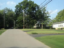
Greenhaw
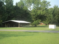 Greenhaw: photo taken at pavilion and well on Greenhaw Road. Greenhaw: photo taken at pavilion and well on Greenhaw Road.
Greenhaw is a farming community north of Cowan situated in a valley along Wagner Creek and below High Top Ridge and Land's End Ridge on the southwest side of Sewanee Mountain. The area was first settled in the 1820's by John and Louise Anderson. The community was situated around a deep spring well that supplied water for homes and livestock for well over a century. A school operated beside the well from the 1880's until 1953. The name was given in reference to the hundreds of hawthorn trees growing in the area.
An old stagecoach road connected Greenhaw with Sewanee to the east and Decherd to the west. This road is listed on some early area maps as Brakefield Road, though it was originally an Indian trail. A popular legend holds that Confederate soldiers buried gold and other valuables in the mountain near the old road during the Civil War. A Confederate cemetery is landmarked and documented in a field along Greenhaw Road.
A Primitive Baptist Church was established at Greenhaw in 1866 near the well. The congregation relocated to Decherd in the 1920's and the church was purchased by members of the Penile Hill Baptist Church about a decade later. Greenhaw Baptist Church was organized and established in this building before relocating into a new building across the street in 1959.
In the early 1900's an effort was made to start an Episcopal church in Greenhaw. Services were held at the local school for a brief period by students in the Theology Department at The University of the South. There's no record of the church's name, if it had one.
The Greenhaw well is still a visible landmark and a community pavilion is located on the site of the original Baptist church. Several Greenhaw residents have pioneer family roots, namely the Gipson's who are descended from Allen Gipson, a prominent Sewanee settler who donated land to The University of the South.
Greenhaw made state-wide news in 2009 when a quiet land acquisition brought the possibility of a rock quarry. The community launched a massive effort to fight the plan and drew in support from surrounding communities and environmental organizations. The campaign to fight the quarry uses the slogan "Keep Greenhaw Green".
Recommended reading: "Before Wagner's Creek Ran Dry", by John Malcom Delzell,
ASIN: B0006RS6VW |
Hawkins Cove
Hawkins Cove refers to the farming valley immediately below Sewanee's Memorial Cross northeast of Cowan. The Hawkins family that owned the cove helped settle both Cowan and Sewanee and contributed land to The University of the South.
Hawkins Cove Road is part of an old stagecoach route that connected Cowan and Sewanee through the better part of the 19th Century. The Squire Brooks Hawkins house, now owned by the Rigsby family, is one of Franklin County's oldest houses and was once a stop on the old stagecoach route.
A sizeable population of Cherokee Indians lived in the area until the 1830's, which made arrowhead collecting a favorite pastime for local residents. The area between the old Squire Brooks Hawkins House and Sewanee Mountain was a burial mound.
The Hawkins family and the Pearson family were closely associated, and the creek through Hawkins Cove right below the Hawkins house is called Pearson Creek. Several members of the Pearson family still live in the Cove.
 The Hawkins-Miller-Rigsby house in Hawkins Cove is one of Franklin County's oldest houses. This is the former home of Squire Brooks Hawkins that was a stop on the stagecoach route to Sewanee. The house was originally a log cabin with an open hallway through the middle. The second story may have been added in the late 1800's. The Hawkins-Miller-Rigsby house in Hawkins Cove is one of Franklin County's oldest houses. This is the former home of Squire Brooks Hawkins that was a stop on the stagecoach route to Sewanee. The house was originally a log cabin with an open hallway through the middle. The second story may have been added in the late 1800's.
|
Hawkins Hill
 Hawkins Hill: photo taken on E. Cowan Street Hawkins Hill: photo taken on E. Cowan Street
Hawkins Hill is the highest point in the City of Cowan. This was the site of Franklin County's First Court House, the pioneer home of Major William Russell. The hill is so named because the Hawkins family purchased this particular land holding from Major Russell in 1815.
The house at the top of the hill was constructed by the Hawkins family over the original footprint of the first court house. Another large house at the top of the hill is the Shook-Wright house. Mrs. Ottie Shook was a prominent Cowan citizen and school teacher who won a Mercury automobile on the "The Price is Right " game show.
 The Hawkins-Russell House at the top of Hawkins Hill is one of the oldest houses in Cowan and the site of Franklin County's first court house. The Hawkins-Russell House at the top of Hawkins Hill is one of the oldest houses in Cowan and the site of Franklin County's first court house.
|
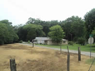
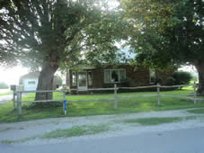
Keith Cove
| Keith Cove is an area immediately south of Cowan named for a prominent family of pioneer settlers. This cove is noted for beautiful mountain scenery and rich farmland. The historic Sloan House is located in the cove and was built by Dr. Flavel Sloan, a surgeon and physician for the Nashville, Chattanooga, and St. Louis Railroad. Keith Cove never developed a commercial trading district because of its close proximity to downtown Cowan. |
Lakeview
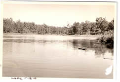 Photo of the lake at Lakeview taken in the 1940's. Photo of the lake at Lakeview taken in the 1940's.
Lakeview was the last group of houses constructed by the Davidson, Hicks & Greene Timber Company. Completed in the late 1920's, Lakeview was a settlement located on top of the mountain southwest of Cowan in a clearing created by the massive logging operation. DH&G built a three-acre lake below a mountain stream to supply water for the company's steam locomotives and steam cranes. The small lake and spectacular view of the Cowan valley earned it the name Lakeview. A small lodging hotel was built for visitors and term residents. A school, commonly known as Cold Spring School, was constructed in the area using two railroad cars that could be moved from one camp to another when necessary. Lakeview was served by a mountain railroad that connected the various logging camps with the enormous sawmill operation in Cowan adjacent to the mainline railroad.
 Photo of the old Lakeview hotel. Photo of the old Lakeview hotel.
Today, there's hardly a trace of old Lakeview. The original houses are gone, the hotel fell to the ground in the 1970's, and the dam that contained the mountain stream gave way causing the lake to dry. There are a few luxury homes built in the Lakeview area with an attractive bluff view, but the lack of a consistent water supply has precluded further development. Several hunting clubs lease thousands of wooded acres around Lakeview.
Also read Memories of a Mountain School Teacher |
Mars Hill / Morris Hill
 Mars Hill: photo taken on Walnut Street Mars Hill: photo taken on Walnut Street
Mars Hill refers to an elevated area in the northwest quadrant of Cowan above Miller branch*. Historically an African-American neighborhood, the name has biblical significance. Some locals believe that the correct name is Morris Hill in reference to a family that lived in the area, and some simply refer to it as "The Hill". Mars Hill covers an elevated area between the railroad and the old Thorogood School.
A relatively large grocery store was operated in the community by Mr. Dewitt Moseley. Mt. Sinai Baptist Church and Thorogood Street Church of Christ are both located in the area as well as well as the Thorogood Cemetery.
*Note - the tiny stream referred to as Miller Branch is not to be confused with Miller Creek. Miller branch flows from High Top Ridge along Greenhaw Road, under the railroad and into Boiling Fork Creek at the former Iron Bridge. Miller Creek flows through Miller Cove and joins up with Boiling Fork east of Cowan near the Hawkins Cemetery. |
McAmis Lane
 McAmis-Sawyer House on McAmis Lane. McAmis-Sawyer House on McAmis Lane.
McAmis Lane is a 1-mile road that connects East Cumberland Street and Highway 41A on the eastern city limits of Cowan to the historic Georgia Crossing Road. Locals also refer to McAmis Lane specifically as a cluster of houses on the northern end of the road where it meets Georgia Crossing.
Most of the houses on the east side cluster were built in the 1970's on sections of land that were part of the old Holder and Miller home place, later purchased by the Forgy's and the Pearson's. Two houses on the west side were owned by the Shedd's and Miller's, of which the Miller house still stands. The cluster also includes houses that front Georgia Crossing Road near McAmis, but on the road itself.
McAmis Lane is unique in that it has two separate and unique connections to Hollywood. The most notorious house on McAmis is undoubtedly the beige-sided house brought into the neighborhood from Decherd in 1991 during the construction of Highway 64. Sasha Mitchell, a Hollywood actor and movie star, leased the house in 1995 in order to relocate his family from California to Tennessee. The move caused quite a stir in Franklin County and created a media frenzy that multiplied the traffic count in this otherwise quiet neighborhood. A true Hollywood drama emerged prompting a visit from the National Enquirer and a controversial story that made its way into the court house and onto The Oprah Winfrey Show. The Mitchell family moved back to California the following year and the neighborhood was quiet again. Since that time the "Sasha Mitchell House" has become a point of reference and a landmark in its own respect.
The oldest home on the lane is the McAmis-Sawyer house built in the late 19th Century. Craig Sawyer, an aspiring Hollywood actor, grew up there and still visits from time to time.
 Former residence of Hollywood actor Sasha Mitchell on McAmis Lane. Former residence of Hollywood actor Sasha Mitchell on McAmis Lane.
|
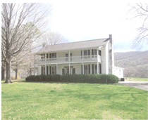
Miller Cove
Miller Cove refers to the farming valley below High Top Ridge and Armfield Bluff on Sewanee Mountain north of Cowan. Miller Creek flows through the Cove on its way to Boiling Fork. The Miller family settled the area and built a large plantation with a large antebellum home at the foot of the mountain. Miller Cove fronts Georgia Crossing Road, but is scarcely populated. The vast land is used exclusively for farming while the side of the mountain leading up to the University Domain is leased for wild-game hunting.
 The Holder-Miller-Forgy-Pearson house, possibly the oldest brick dwelling in Franklin County, is located on the south end of Miller Cove. The Holder-Miller-Forgy-Pearson house, possibly the oldest brick dwelling in Franklin County, is located on the south end of Miller Cove.
|
Slagtown
 Slagtown: photo taken from S. Tennessee Avenue. Slagtown: photo taken from S. Tennessee Avenue.
Slagtown, or Slag Town, is one of Cowan's oldest neighborhoods. The area was originally the site of the Sewanee Furnace that made Cowan the largest producer of pig iron in the South. One of the by-products of the iron smelting process was enormous mounds of slag, a metallic rock substance. The Tennessee Coal and Iron Railroad Company, which owned the furnace, constructed dozens of houses near the slag piles, hence the name Slagtown.
Most of the houses were demolished in the early 20th Century after the Furnace closed and relocated to Birmingham. However, in the early 1920's the Davidson, Hicks & Greene Timber Company constructed another neighborhood of one-family homes as well as a boarding house near the slag piles. This development also took the name Slagtown.
 Photo of the original Slagtown that was built by the Sewanee Furnace company. All of the houses have long been demolished and the area is now farmland. Photo of the original Slagtown that was built by the Sewanee Furnace company. All of the houses have long been demolished and the area is now farmland.
|
Tantallon
Tantallon is a local mystery, and some people claim it's a ghost town. Located along the railroad south of Cowan, beyond the Cumberland Mountain Tunnel and along Crow Creek, the only visible indication of the town's existence is a railroad marker. The town may have been populated by a few railroad workers operating and maintain a track switch by the same name, which was common practice before the development of automated signal systems and two-way radio.
It's possible that the switch was named Tantallon by a railroad worker from Scotland who helped build the Cumberland Mountain Tunnel, and who recalled the name of Tantallon Castle in his native land. Evidently a scattering of houses developed near the railroad switch that was referred to colloquially as Tantallon. A map of Franklin County from the early 1850's references Tantallon along with the only other "town" that existed in the Crow Creek valley, Anderson, down on the Alabama state line. (This was about 20 years before the town of Sherwood was organized.) Tantallon is isolated, accessible only by railroad or by a railroad-controlled access road. |
Vanderbilt Drive
| Vanderbilt Drive specifically refers to a street in the northeast quadrant of Cowan, but colloquially refers to a group of houses on and near Vanderbilt Drive built during the post-World War II housing boom. Most of the houses are a low-profile ranch design with extra-large windows in a style that defined America suburbia for almost a generation. Most of the homes in Vanderbilt were built by prominent Cowan business owners and other well-known families. |
|
